Treaty #3 Geoportal Launch
Grand Council Treaty #3, Territorial Planning Unit is pleased to announce the official launch of the Treaty #3 Geoportal.
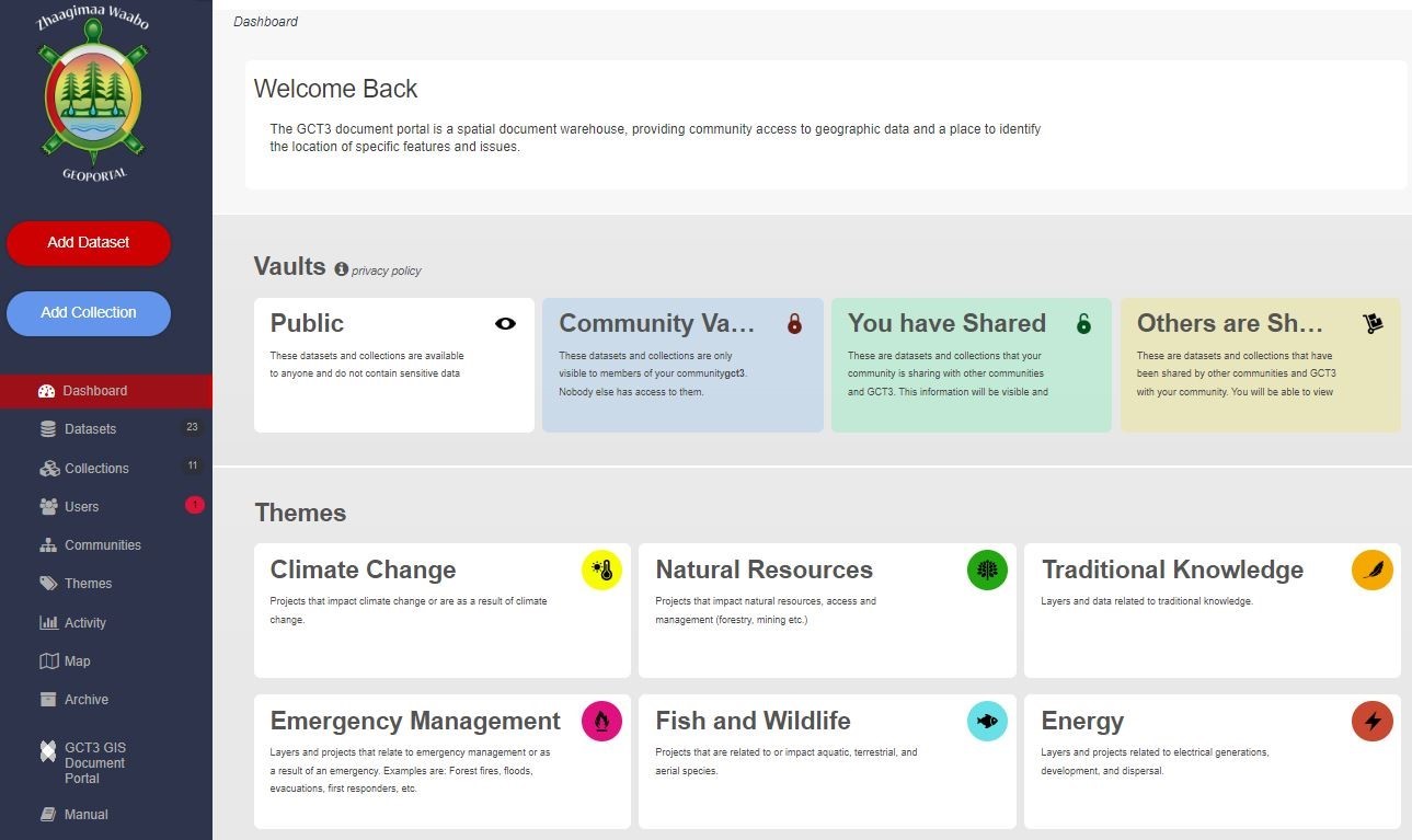
The Geoportal is an interactive tool for data storage and sharing across the Anishinaabe Nation in Treaty #3. The Geoportal allows Treaty #3 communities and organizations a secure location to store and share data, alongside public information acting as a comprehensive solution for all data needs. Through the portal the Anishinaabe Nation in Treaty #3 and Treaty #3 communities can view and share information across the 55 000 square miles of the Territory to understand ongoing resource activities, economic opportunities, identify gaps, share knowledge and teachings and protect sacred sites throughout the Territory that will support decision making as a Nation through Manito Aki Inakonigaawin (Treaty #3 Great Earth Law).
“Our protocols through Manito Aki Inakonigaawin and decisions as a Nation are based on Anishinaabe knowledge and supported through Western Science,” said Ogichidaa Francis Kavanaugh. “Data is a driver to all negotiations, actions and upholding our responsibilities to mother earth. Today we take a huge step forward in asserting data sovereignty in Treaty #3 and this portal will provide a foundation on which we can move forward together.”
The purpose of the Geoportal is to support the Anishinaabe Nation in Treaty #3 and communities to access, protect, and share public and private spatial and non-spatial data. Communities will be able to upload and save projects and documents as well have access to online mapping tools with diverse collections of Treaty #3 specific data layers. The Geoportal provides the ability to have singular community access, access shared between multiple communities, and as a Nation for each piece of data saved. Documents like impact assessments, forest management plans, land use studies, mineral surveys, emergency plans, housing developments and project outlines can all be connected with spatial GIS layers to make custom maps or share with project teams.
“There is so much going on in Treaty #3 Territory that we needed a place to track it all and the Geoportal provides that home for all our data. Now we can continue to effectively make decisions that protect our inherent and treaty rights and community members for future generations,” said Chief Lorraine Cobiness. “Treaty #3 Territory is shared by all 28 Treaty #3 communities and this tool supports us in continuing to work together and assert Anishinaabe jurisdiction and decision making across the Nation.”
Moving forward, Grand Council Treaty #3 will support the implementation of the database by the upload of data and update of relevant Treaty #3 information and host training events across the nation. GCT3 will add new map layers, documents, and projects when they become available, and offer training and implementation upon request of communities and technicians. Work has already begun on creating a new phone app to create new GIS layers right to the Portal, making it even easier to input projects, sightings and plans.
If you are interested in accessing the Treaty #3 Geoportal, click the link to access the Geoportal Log-in page. From there, click the “Register” button and create a user. Once our administrator accepts your registration, you will have access to both the Geoportal and the Geoportal Demo. A geoportal manual is available to make using this new tool even easier. Please have patience as the Grand Council Treaty #3 team reviews all applications to ensure the safety and security of the Anishinaabe Nation in Treaty #3 data and access.
-30-
For more information please contact:
Raeshawn Parsons, GIS Specialist Email: Raeshawn.parsons@treaty3.ca or Geoportal.admin@treaty3.ca